Notes on driving the trail route
(Scroll down below the map)
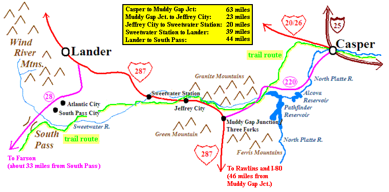
As the map above shows, a drive through the country covered by
this stretch of trail can be done on pavement by following Wyoming route 220 from
Casper to Muddy Gap Junction, then following US 287 to about 10 miles south of
Lander, and finally taking Wyoming 28 across South Pass. But as the map shows, these
highways contact the actual trail route in only a few places. There are several unpaved
roads that (in good weather) can be traveled by most passenger cars
to get closer to the actual trail.
The Oregon Trail Road provides an alternate route from the Casper area
to Highway 220 near Pathfinder
Reservoir. It can be accessed in one of two ways:
Follow Poison Spider Road west from Casper over Emigration Gap. Just
over a mile-and-a-half past the old Poison Spider School, turn left (south)
onto County Road 319. A mile later bend to the right onto Oregon Trail Road.
This approximates the route most emigrants would have followed
if using the ferry at what is now Casper.
Follow Highway 220 about 6 miles southwest of Casper to Bessemer Bend and cross
the North Platte River there. Proceed west on dirt road about five miles to the
junction with Oregon Trail Road. This closely follows the main route used
before the 1847 establishment of the ferry at what is now Casper, as well that of groups
after 1847 (including the Mormon handcart companies) who
wished to avoid the ferry fees by fording the river here.
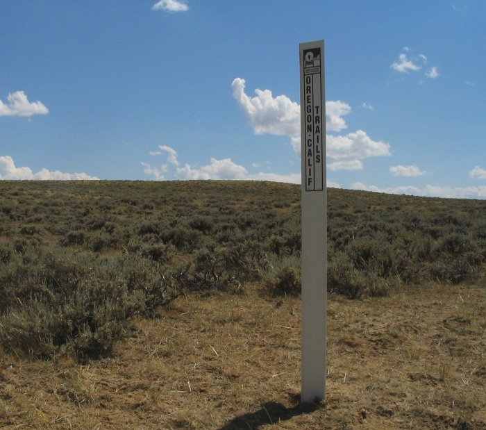
The Oregon Trail Road closely follows the trail route, with ruts of the trail
visible in several places. (The USGS quad maps show the trail route, and you can
additionally watch for the white historical
trail markers.)
Landmarks it visits include Avenue of Rock, Willow Spring, and
Prospect Hill. Contact the
Casper BLM office for road conditions.
Bison Basin Road leads south from Highway 789 just east of the bridge
across the Sweetwater River at Sweetwater
Station. In just over two miles this road is
crossed by the trail route, which can be followed west (the east branch dead-ends at
a private land boundary)
some distance by driving (if you have a high-clearance vehicle) or walking
a dirt track. This track leads in just a few miles
to a beautiful view of the Sweetwater Valley and the descent to the 6th crossing.
The Hudson-Atlantic City Road turns south from Wyoming Highway 287 about five
miles west of Sweetwater Station. This generally parallels the trail, though it stays
a few miles north of and higher than the actual route. In a few places the road comes out
at the edge of the ridge and offers great views of the Rocky Ridge / Lewiston Lakes
area. The road ends at Atlantic City near South Pass. Allow at least a couple of
hours for one-way travel. Contact the
Lander BLM office for road conditions.
Possible high clearance side trips off this road:
At Silver Creek a side road (marked by a BLM sign) leads to the lower part of Rocky
Ridge. The Rocky Ridge climb itself is closed to vehicle travel above where this road
joins it, but from that point it is only a short hike to the roughest stretch of
trail on the entire Oregon Trail route.
Just below Diamond Springs another side road (also marked by a BLM sign) leads
about two miles
to the Lewiston Lakes at the top of Rocky Ridge. While a high clearance vehicle is
needed to drive this road, it's only a couple of miles to hike the road to the lakes.
If you have the high clearance and drive to Lewiston Lakes, you can follow the trail
route west from there all the way to Rock Creek -- but be warned, this is a pretty
rough road in places!
At Strawberry Creek there is a cutoff leading about two miles to
the Lewiston Road (which here follows the trail route).
From where this cutoff road joins the Lewiston Road, it is only about
a mile west to the Mormon cemetery site at Rock Creek (see detail map links
in the photo tour section).
A well-maintained gravel road leads from there to the Atlantic City area.
Oregon Buttes Road turns south from Wyoming Highway 28 at the top of the
hill southwest of the bridge over the Sweetwater. In just under 3 miles this road is
crossed by the original trail route, and either walking or driving this dirt track
one mile to the west brings you to the actual spot where the trail crossed South
Pass. (Highway 28 crosses South Pass a couple miles north of here.)
There are other roads in the area that will take a determined visitor to even more
locations on the original trail. Much of the trail is on private land -- be sure to
obtain appropriate permission before attempting to cross these places.
Good maps are essential, and map websites such
as TerraServer-USA (see the many
links in the photo tour section) are a good place to start. Advice from the
BLM field offices will also help greatly.


 As the map above shows, a drive through the country covered by
this stretch of trail can be done on pavement by following Wyoming route 220 from
Casper to Muddy Gap Junction, then following US 287 to about 10 miles south of
Lander, and finally taking Wyoming 28 across South Pass. But as the map shows, these
highways contact the actual trail route in only a few places. There are several unpaved
roads that (in good weather) can be traveled by most passenger cars
to get closer to the actual trail.
As the map above shows, a drive through the country covered by
this stretch of trail can be done on pavement by following Wyoming route 220 from
Casper to Muddy Gap Junction, then following US 287 to about 10 miles south of
Lander, and finally taking Wyoming 28 across South Pass. But as the map shows, these
highways contact the actual trail route in only a few places. There are several unpaved
roads that (in good weather) can be traveled by most passenger cars
to get closer to the actual trail.